More Atlantic Coast ChartsView full List
-
13308 - Fox Islands Thorofare

-
12207 - Cape Henry to Currituck Beach Light

-
11548 - Pamlico Sound Western Part

-
11522 - Stono and North Eclisto Rivers

-
11524 - Charleston Harbor
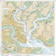

This is one section of a 'small craft' folio chart book, for mariners navigating waters close to shore. The orientation maximizes navigation information and is not necessarily oriented north south.


ARTiPLAQ™ is a family-owned company in Maine providing
exceptional quality custom plaque mounting. Made in the USA.
© ARTiPLAQ™ Terms of Use Privacy Policy